HUNDESCHLITTENTOUREN
POLARLICHTERJAGD & TOUREN
ANDERE WINTERAKTIVITÄTEN
GANZJÄHRIGE PRODUKT
SOMMERAKTIVITÄTEN
AUSRÜSTUNGSVERLEIH & Autotransfer
PROFESSIONELLE WEITERBILDUNGSKURSE
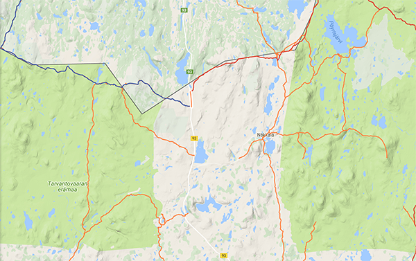
Tarvantovaara Wilderness Area is located west of the village of Leppäjärvi and north of the village of Kaaresuvanto. The Southern boundary of the wilderness area more or less replicates the northern limit of pine forests and its northern boundary lies in fell tundra, along the Finnish-Norwegian border. About a third of the area is mire and the mires are mainly palsa bogs, which are bogs with frost mounds rising from them. The most common trees are fell birch and the highest peaks are over 600m above sea-level.
Trails to the wilderness cabin at Salvasjärvi are described in the 'Hetta Trails' section.
15km quad-bike trail from Salvasjärvi to Harkajärvi across the open mountain range. This trail leads onto the high tundra north of Stuorrahanoaiv. To the north of Harlkajärvi, the mark is a parallel slope. At the beginning of the gate of the reindeer gate and far beyond the yellow-painted border rocks, the route joins Karesuvanto into the old market path to Kautokeino. Monkijaura. Avointa tunturimaata. Lyhyt kivkkoinen ja pienipiirteinen osuus Stuorrahanoaivin pohjoisrinteessa, taalla monkijaura katoaa. Harlkajarven pohjoispuolella marka sarainen rinnesuo. Alkaalla poroaidan portin ja kauas nakyvan keltaiseksi maalatun rajakivipaaden luona reitti yhdistyy Karesuvannosta Kautokeinoon menevaan vanhaan markkinapolkuun.
Kivilompolo Customs via Salvasjärvi to the village of Kultima


The second map shows the 2.06km section of road that you have to bike down to reach the Tarvantovaara trails from Kivilompolo.
The third map shows the 16km trail between Kivilompolontie and Salvasjärvi. It is a scenic mountain trail which crosses the Norwegian border, and is much used, muddy and sometimes rocky.
The fourth map shows the 16km trail between Kivilompolontie and Salvasjärvi. It is a scenic mountain trail which crosses the Norwegian border, and is much used, muddy and sometimes rocky.
The last-but-one map shows the 15km trail between Salvasjärvi-Härkäjärvi across the tundra. The short, small and small part of the Stuorrahanoaiv north, here the quadrangle disappears. In the north of Härkäjärvi there is a wet alpine slope. At the beginning of the gate of the reindeer gate and far beyond visible yellow-painted border sculptures, the route joins Karesuvage into the old market path to Kautokeino. Mönkijäura. Avointa tunturimaata. Lyhyt kivkkoinen ja pienipiirteinen osuus Stuorrahanoaivin pohjoisrinteessä, täällä mönkijäura katoaa. Härkäjärven pohjoispuolella märkä sarainen rinnesuo. Alkaalla poroaidan portin ja kauas näkyvän keltaiseksi maalatun rajakivipaaden luona reitti yhdistyy Karesuvannosta Kautokeinoon menevään vanhaan markkinapolkuun.
The last map shows the 24km route between Leppäjärvi and Kultima. It is an old track marked with mile signs and starts / ends with the bridge across the Palojoki. Reitti tunturikoivua kasvavaa kumpuilevaa hietikkokangasta. Once you reach Kultima, you need to follow the gravel road for 13km until it hits the main road at Kuttanen.
Around Palojoki and the Wilderness Area Itself


The third-last map shows the 22km trail between Salvasjärvi and Kultima. Mönkijäura. Pitkospuita ja siltoja..
There is a 16km quad-bike trail along an old lost track between Palojärvi and Salvaspaa - only for the adventurous.
(MAP MISSING)To the North, towards Kautokeino
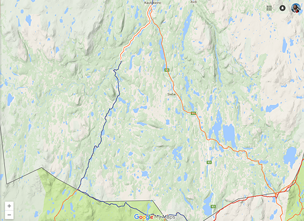


The top map shows the 13km asphalt section of the trail from Aksomuotki, SSW of Kautokeino, to Kautokeino. This continues on the trail shown in the second map, to the border, along the old border-crossing road between Raja and Kivilompolo. This is a 15km section of trail which starts on a sandy beach on the NW corner of Kaamusjarvi and uses boardwalks and bridges to cross marshes and streams.
The 29.7 km trail between Härkäjärvi-Aksomuotli (marked in blue, on the map) leads from the reindeer gate into some dense scrub where the trail is not clearly marked. You should still be able to pick up the old trace, however, from time to time. The route passes through the Favrusjokkan tundra and continues there clear towards Galanita. Galan is wasted on Sallanjohkan (Roggejohka), following the track of the ATV, on the opposite side there is also an old house. From the house begins a clear quad bike towards the road. The cargo log is crossed in Aksomuotti along the highway. This is about 10 miles along the asphalt road. Rajalla olevan poroaidan portin jälkeen jälki katoaa pensaikkoon. Vanha jälki on kuitenkin löydettävissä heikkona jäkälien ja varpujen peittämänä urana selänteen koivikkoisella rinteellä. Reitti kulkee Favrusjokkan tuvan kautta ja jatkuu sieltä selkeänä kohti Galanitua. Galanitussa kahlataan Sallanjohkan (Roggejohka) yli seuraten mönkijän jälkeä, vastarannalla on myös vanha talo. Talolta alkaa taas selkeä mönkijäura kohti maantietä. Kautokeinojoki ylitetään Aksomuotkissa maantiesiltaa pitkin. Kautokeinoon on tästä matkaa n10km asfalttitietä pitkin. The last 13km section of this trail (not too far north of the distinctive dog leg) is on asphalt.
The last map shows the 41km trail between Kautokeino and Siccajarvi. c. 20km of the trail is on asphalt and 14km on a tractor road. Siccajarve has a Norwegian Fjelstation, where you can stay overnight. The last 8km unhighlighted section of this trail which leads to the border (Siččajarvi-Raja) starts from the West of lake Sicca. and roughly follows the direction of the stream, south, along shallow sand dunes.
The Kaaresuvanto-Lavivaara - Syväjärvi Trail (20km)
This trail has its starting point at the village of Kaaresuvanto and it leads to Lake Syväjärvi via Lavivaara Hill, at which point it changes from a gravel road to a dirt track. The trail is marked with kilometre posts, as are all trails maintained by the Finnish Road Administration. The terrain is undemanding although it is a bit rocky at the Syväjärvi end.
Services: Syväjärvi open wilderness hut.
If you are interested in a longer, wild and demanding trip, you can continue on from here via Puussasvaara to Neuhkana and then again to either Hirvasvuopio and Munnikurkkio, or via Kalkuaivi to Kelottijärvi. Some of these trails are described in the next section about biking in the arm of Finland. Remember, however, that the section from Saarikoski via Raittijärvi to Munnikurkki.
Kaaresuvanto via Syväjärvi and Puussasvaara to Neuhkana trail for expert riders


The first map shows the 26km Karesuvanto-Harkajarvi trail. In the south of Sorata and Lavivaara there is easy access to the Syviarvelle and still a poorly lit but clear and easy walk to the Hietakerö and Harkajarve and the reindeer route to the border. The groove leading to Kautokeino, north of the Jaam River, branches to the right and is less used than the rogue that leads to Rupisuolijarve. Etelassa soratie ja Lavivaaran jalkeen helppokulkuista monkijauraa Syvajarvelle asti ja edelleen vahemman kayttya mutta selkeaa ja helppokulkuista monkijauraa Hietakerolle ja Harkajarvelle ja rajalla kulkevalle poroaidalle. Jaamijarven pohjoispuolella Kautokeinoon johtava ura haarautuu oikealle ja on vahemman kaytetty kuin paaura, joka johtaa Rupisuolijarvelle.
The middle map shows the 10km trail between Karesuvanto and Baktejohka. The trail starts at the Lavivaara road, c. 50m south of the Baktejohkan bridge. There are old disused boardwalks on the trail.
The last map shows the 10km section of trail between Karesuvanto and Baktejohka. It starts at the Lavivaara Road, c. 50m south of Baktejohkan bridge. Beware that there are old disused boardwalks along the trail.
It is 36km from Karesuvanto to Harkajarvi. A gravel road to the south of Sorata and Lavivaara, leads to easy access to Syvijärvelle and then a less well marked but still distinct and easy quad-bike trail to the Hietakerö and Harkajarve and the reindeer route to the border. The trail leading to Kautokeino, north of the Jaam River, branches to the right and is less used than the one that leads to Rupisuolijarve.


